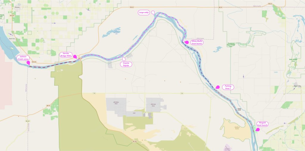
Hanford Reach in south-central Washington state is the last non-tidal free-flowing section of the Columbia River. It’s a very scenic area to paddle, but relatively remote and with very limited take-out points. It is typically done as a single day 19-mile paddle, but can be extended and split across a couple of days if desired, possibly in conjunction with hiking some trails along the Reach.
By far the most popular segment for paddling is from Vernita Bridge to White Bluffs Boat Launch, around 19 miles; this typically takes between 4 and 6 hours. The National Park Service has some very helpful information about this segment, which they characterize as a class 1 float except for one section of easily-avoided class II rapids. It is fast and can be strenuous, with some swirling currents / whirlpools, gravel bars and motorboat wakes. In salmon season starting in September, there can be lots and lots of motorboat traffic. Wind is common mostly in the afternoon and can slow you a great deal, as well as make paddling much less pleasant. Most of the info from the NPS is applicable to the entire Reach.
Other segments along the Reach immediately upstream and downstream of the most popular route can be paddled instead or in addition: a 6-mile segment from Jackson Creek Fish Camp to Vernita Bridge; an 8-mile segment from White Bluffs Boat Launch to the next take-out (a sign refers to this as Parking Area 7); and a further 8-mile segment to the Ringold WDFW site. One can continue beyond Ringold, but I have not done or researched this. The river slows significantly before it reaches Richmond, and I would expect this section to be easy but slow and not particularly interesting. I have paddled a little at Richmond, and paddling upstream was easy. I do not know if that would be the case below, where the Yakima River joins the Columbia.
General Notes
- Recommended flows: NPS says that all levels are boatable and characterizes 80,000 – 120,000 cfs as “moderate”. I have paddled this at 120,000 cfs and 170,000 cfs, and at the higher water flow there was noticeably more turbulence just below Vernita Bridge and around Coyote Rapids. Also at the higher water flow we steered clear of a big eddy on river left as we reached the bluffs, out of some concern for stability there. I would probably advise against a tight river-right turn there as well — go straight towards the bluffs, between the two islands. These islands are very low and can be hard to distinguish until you get very close.
- The water flow is regulated by Priest Rapids Dam, and the river level can quickly rise or fall up to 10 feet during a day.
- Wind is common and can significantly impact paddling times.
- There is no shade and very limited options for stopping. Bring sunscreen and dress appropriately: I recommend a hat and sunproof clothing.
- The water temperature is very cold even in hot weather. Avoid cotton clothing.
- Suitable for sea kayaks, canoes, and I have heard of some taking paddle boards. (It is a rocky area and I have taken my thermoformed Eddyline kayak here on my trips, but personally I would be willing to take my fiberglass boat if that’s all I had. I have not seen evidence of rocks hiding just below the surface, though there is a shallow section downriver of the White Bluffs boat launch which had me wondering how shallow it would get.)
- Motorboats and their wakes may be hazards. I encountered almost no traffic in my two early Spring trips, but when visiting in the Fall the river was packed with boats zipping up the river to fish for salmon. In my opinion it is not worth trying to paddle when the traffic is like that.
- The Department of Energy’s side of the river (river right; south and west shores) is closed above the high water line, as is river left before White Bluffs boat launch.
- The best time of the year to do this paddle may be late April / early May. Weather should be warmer but not yet super hot; water level is probably pretty good in this period (probably faster than later in summer); and motorized boat traffic should be relatively low (it’s not the busy Fall salmon season, and the White Bluffs boat launch is officially closed to motorized boat launches in this part of the year, though that’s not well-advertised and I have seen a few boats launching here in May).
- Sea kayaks are appropriate for paddling the Reach. I have taken thermoformed Eddylines on my trips, and other than the shallow section which made me a bit nervous past the White Bluffs Boat Launch, I had no concern about hitting or scraping.
- This is rattlesnake country, and you should certainly keep an eye out if you do any hiking in the area (there are some interesting trails around White Bluffs). You will often see mule deer, many bird species, and possibly coyotes.
Main Segment: Vernita Bridge to White Bluffs Boat Launch
This is the segment that most paddlers do and which is what is commonly meant when referring to paddling the Reach. It can be combined with segments before and/or after it for a longer paddle, though you may want to split the paddle into multiple days. Various old nuclear reactor buildings can be seen on the Hanford Site to river right, and the White Bluffs especially are very scenic, with swallows swirling around the base at one point.
The National Park Service has some very helpful information about this segment.
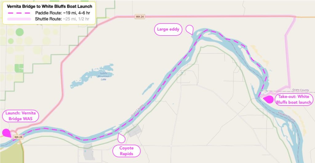
- Distance: Appx. 19 river miles
- Alternate launch point: Jackson Creek Fish Camp, adding 6 miles to the trip ($10 overnight camping). There is not a formal boat launch here, but there is a paved path leading down close to the water and it’s easy enough to launch from there.
- Duration: 4–6 hours is typical.
- This took me 4.5 hours at 111 kcfs, and a mere 2.5 hrs at 170 kcfs (not including time spent stopping for lunch). Paddling both trips was pretty casual (especially the 111 kcfs trip), and we stopped paddling at the White Bluffs, drifting the rest of the way to the boat launch.
- Shuttle: appx. 25 miles, 30 minutes
- Rating & Hazards: Class 1 (except for Coyote Rapids, class II but easily avoided; see below).
- Considered safe for “advanced beginners” (someone with some paddling experience), but it is fast-flowing, and can be strenuous, with swirling currents and gravel bars.
- High winds can create sizable waves in addition to slowing you tremendously.
- Coyote Rapids [map] on river right is class II but which can be easily avoided by staying left of it.
- At high water flows a major eddy [map] forms on river left where the river bends at the beginning of the bluffs, causing turbulence and even reportedly some difficulty escaping the eddy at especially high flows.
- Launch Point: Vernita Bridge Water Access Site [map] [WDFW page] [Boondockers Bible description]
- The WDFW page says there is no camping here, but various camping sites claim there is and I have seen large numbers of RVs etc. set up here in salmon fishing season. I consider it very unattractive for tent camping, at least: there are no facilities other than porta-potty, virtually no shade, and the ground is mostly covered with rocks which would make pitching a tent difficult, not to mention uncomfortable
- Take-out point: White Bluffs Boat Launch [map]
- Does not allow motorized launches between November 1 through June 30 (this stretch of the river is a sanctuary for over-wintering waterfowl). That said, I have seen a few motorboats launching there in Spring.
- Porta-potties
- No camping
- No water
- 5-mile gravel drive off the main road
- Hours: Sunrise to sunset
- Landmarks: when the river bends right, taking you away from the bluffs, you are almost at White Bluffs Boat Launch on river left.
Earlier Segment: Jackson Creek Fish Camp to Vernita Bridge
This is a short segment which can easily be combined with the following segment for a longer trip. The mountain ridge on river right for the first part of this segment is quite scenic.
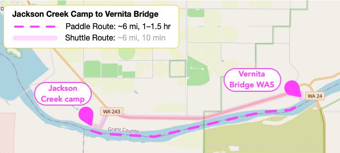
Probably want to stay river left once you start getting close to Vernita Bridge, so you can easily make the take-out.
- Distance: Appx. 6 miles
- Duration: 1–1.5 hours at a casual pace?
- This took me a little over an hour at 125 kcfs, and a little under an hour at 170 kcfs, paddling casually.
- Shuttle: 6 miles, 8 minutes
- Rating & Hazards: Class 1?
- I haven’t seen an independent rating, but in my experience this is the easiest segment and I didn’t observe any hazards, though the river is fast flowing.
- Launch point: Jackson Creek Fish Camp [map] [Grant PUD page (scroll to desired entry)]
- There is no boat launch here, but there is a paved path down to the river (used primarily by people fishing), and it’s not difficult to launch from there.
- ADA vault toilet
- No potable water
- Campground ($10/night). Camp sites are gravel, with picnic tables.
- Take out point: Vernita Bridge Water Access Site [map] [WDFW page] [Boondockers Bible description]
- The WDFW page says there is no camping here, but various camping sites claim there is and I have seen large numbers of RVs etc. set up here in salmon fishing season. I consider it very unattractive for tent camping, at least: there are no facilities other than porta-potty, virtually no shade, and the ground is mostly covered with rocks which would make pitching a tent difficult, not to mention uncomfortable.
- Porta-potty
- No water
- Permit: Discovery Pass required
- Additional toilets are at the rest area on the other side of the bridge.
Additional Segment: White Bluffs Boat Launch to Parking Area 7
This segment is best done either in conjunction with the section before it or the section after it, as it is fairly short and requires a long, very indirect shuttle (you have to drive outside the national monument, down to Ringold, and then up along the river to the take-out point). It remains scenic, however, as you continue to paddle down along the bluffs.
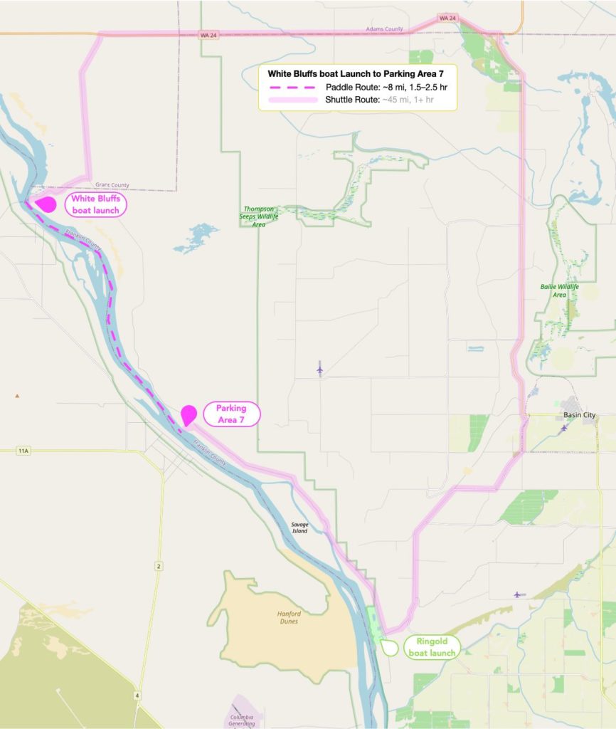
(There is a road in the national monument between White Bluffs Boat Launch and Ringold Fish Camp which you might be tempted to take, but this is prevented by a 3-mile segment which is closed to motorized vehicle traffic. It is open for walking or biking, but few miles of heavy gravel at the north end probably makes a bike shuttle undesirable.)
- Distance: appx. 8 miles
- Duration: typically 1.5–2.5 hours at a casual pace?
- This took me a little under 2 hours at 111 kcfs, and a little over 1 hour at 180 kcfs. (At a casual paddling pace.)
- Shuttle: appx. 45 miles and 1+ hours (the segment approaching Parking Area 7 is largely unimproved)
- Rating and Hazards: Class 1? (But the river remains swift and there is one shallow section.)
- I haven’t seen an independent rating, but in my experience this was similar to the previous segments. However, there is a section where the river got quite shallow, and as the river remains swift here I was eyeing it nervously, though did not have any problem on either trip.
- If I recall correctly, this is the section where we started occasionally encountering large, seemingly-random boils in the water. These did not prove to be destabilizing for us, but were unexpected and their random nature meant they could not simply be avoided. (At the higher flows, these boils were more of an issue on the next segment, just as we approached Ringold.)
- Launch Point: White Bluffs Boat Launch (see above for description)
- Take-out Point: Parking Area 7 [map]
- I can’t remember if there was a porta-potty here. The take-out is unimproved.
- Permits: none
- Landmarks: You will pass under very large power lines shortly before reaching the take-out on river left. The actual take-out is not very prominent.
Additional Segment: Parking Area 7 to Ringold Springs WDFW Site
This is another short segment. In my opinion this is not as appealing as the earlier segments, but still nice, and can be convenient if you are camping at Ringold.
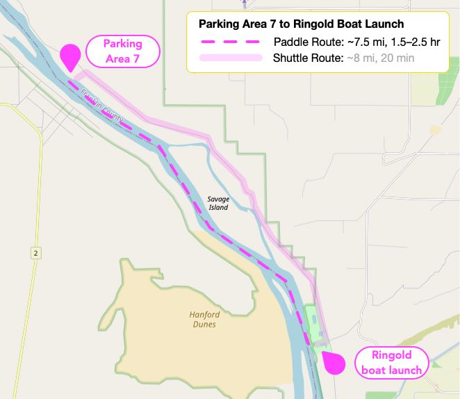
- Distance: appx. 7.5 miles
- Duration: around 1.5–2.5 hours at a casual pace?
- This took me a little under 2 hrs at 115 kcfs and about 1.5 hrs at 160 kcfs.
- Shuttle: appx. 8 miles and 20 minutes (this is largely unimproved road)
- Rating and Hazards: Class 1+? (The river remains swift, and unpredictable boils became more prominent near Ringold, requiring additional attention. Paddling near the shore on river left should alleviate this.
- Launch Point: Parking Area 7 (see the above section for more details)
- Take-out point: Ringold Springs Boat Launch [map] [WDFW page]
- The boat launch is at the south end of the Ringold site. You are not supposed to launch or take-out elsewhere along the site.
- ADA vault toilets
- Camping: primitive (3 day limit)
- Camping is both north and south of the water channel feeding to the
- No water
- Permits: Discovery Pass
Camping & Lodging
There is no camping (and no open fires) within Hanford Reach National Monument. Camping options nearby seem to be limited, and none of the ones I’m familiar with have showers.
There are certainly hotels around Richmond, and I expect around Othello as well.
Ringold Springs immediately below the national monument has primitive camping, limited to 3 days; Discovery Pass required. No water. Vault toilets. The south area has no shade; the north section has some, but the shaded areas can be overgrown. Areas can be very rocky.
Jackson Creek Fish Camp (above the national monument; just below Priest Rapids Dam) has a limited number of $10/night camp sites. The sites are gravel, and have picnic tables, but no water, and only vault toilets.
Resources
- Weather info
- 13 miles ESE of Mattawa WA weather conditions and forecast from weather.gov
- Fire and smoke map of the general area from Airnow.gov
- Wind forecast from windy.com
- Water levels
- Snoflo flow report for Columbia River below Priest Rapids Dam (good page with weather and historical comparison)
- USGS River Gauge 12472800
- Weather.gov gauge PRDW1
- Notes
- The official US Fish & Wildlife Service site for Hanford Reach National Monument. (Disappointingly the map does not really have enough detail. One thing it fails to show is what sections are “open”, as not all of the national monument is open for hiking. The pages mention some of this, but I can’t find anything showing the pertinent borders.)
- The National Park Service has a page on Paddling the Hanford Reach.
- Mountaineers trip report from a group that paddled the entire stretch from Jackson Creek Fish Camp 6 miles above Vernita Bridge) to Ringold in one day, at 270k cfs. The fast flow made for a “monster eddy” they had to fight their way out of when the river turns at the white cliffs shortly before the take-out point.
- Professor Paddle forum thread about paddling the Hanford Reach
- Wenatchee Outdoors post about a trip from Vernita Bridge to White Bluffs Boat Launch under excellent conditions (fast water, no wind) which took under 3 hours.
- Fishing report from Sept 2020 with some interesting info from 2019 and 2020. (River was lousy with boaters when we tried to go 2020-09-25. Masses of boats around Vernita Bridge and White Bluffs, and an endless stream of boats heading upstream from Ringold starting by 5am. With all the people arriving so early, it made it impossible to sleep to a decent hour in our campsite. 20+ knot winds were what actually what caused us to give up on the paddle, however.)
- Ringold River Road is closed to cars for a three-mile section starting on the north end at White Bluffs viewpoint (a bit south of White Bluffs boat launch). However, it’s paved much of the way and is open to hikers, bikers, and equestrians. (Watch out for rattlesnakes.) The drivable section has some nice views, especially of the north end of Savage Island, and the walkable section also has some beautiful views, especially at the north end where it is well above the river.
- A Fish & Wildlife Service Ranger who leads guided paddles through the Reach gave me some great details before my first trip when I asked on Facebook. Most of those details have been incorporated into this page, with some additions and modifications based on my subsequent experiences paddling the Reach.
Hiking
- White Bluffs – North Slope is a lovely and dramatic trail (if indistinct beyond a certain point). Very windy when I was there, resulting in lots of sand blown into face.
- White Bluffs – South Slope is a longer trail which can be hiked from either the north end or the south end, and can be done either as a loop or an out-and-back either along the top of the bluff or on the road (closed to vehicle traffic) down near the river.